
- Distance: 4 miles
- Difficulty: easy coastal walk leading back through well kept countryside paths, can be muddy on part of it if you go after rain.
The Need To Connect With Nature
I just had to get out, even though the forecast was predicting rain and strong winds on my day off! Sometimes you just have to commit and go anyway, don’t you?
The week just doesn’t feel the same when I’m unable to get out into nature and hear the birds and smell the undergrowth for a few hours.
Admittedly, this walk was supposed to be around 8 miles long originally and is easy to lengthen if you want to do that. You just need to cross over the river and do a loop around Walberswick before coming back. However, a look at the sky told me that it would be wise to cut it a bit short, that and the fact that we didn’t put enough money in the machine at the car park to last for the full length of the hike! Oops.
Transport To Southwold
To get to Southwold using public transport from Norwich there is a direct bus, which will take about an hour and a half from St Stephens Street in Norwich using Border Bus. Here is the link for you to the current timetable at the time of posting: https://www.border-bus.co.uk/media/docs/146_Timetable.pdf
Arriving by car you need to head towards the Southwold Pier pay and display car park where there was plenty of space at this time of year on a Friday.
I managed to get some video footage for you to be able to see the terrain a bit, but it was lightly raining for most of the walk which made me a bit conscious of not having my camera out for too long as I didn’t want to get it wet.
Starting The Walk, and Lunch Options
We didn’t get to Southwold until around 12 o’clock, so we thought it would be a great idea to have some lunch before setting on. We settled on fish and chips (well, chips and mushy peas for me actually 😉 ) – there are several fish and chip shops and eateries to choose from in the area, and a little way into the walk there are two or three more places in the harbour that you will pass through. Lots of opportunities for you to warm your cockles if you go in chillier weather.
Map Of The Route
Here’s an image of the route that I took which didn’t join up because I forgot to turn it on right at the beginning in the car park (eye roll), so I switched it on in the centre where the green dot is after we’d finished our chips.
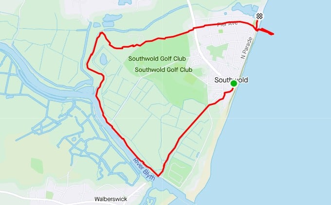
As you can see, it goes southwest, first along the coast a little way before taking a route that goes parallel to the sea a little inland along a footpath. Follow the arrow to the right when you are on the coastal footpath. You will follow the road a little way down the hill and at the bottom is an obvious footpath which is tucked behind the sea defence mound next to the fields. At the end of the path cross over the road and go right following the River Blythe through Walberswick harbour.
Walberswick
The harbour is beautiful and there are a couple of places to get fish and chips and fresh fish as well as a cafe if you’d like to stop there.
Continue on past all the boats and you will find a footpath which continues to follow the river.
Just after the footbridge which crosses over the river, the path veers to the right and takes you across the fields where there may be cows grazing (they seemed quite friendly!). Keep on the raised path in front (it was quite muddy when we were there after some heavy rain the last few days, but not impassable).
Cows…
When you reach the end of the cow field there will be a gate to pass through and you will take the path to the right which takes you up through some gorse bushes close to the golf course and presents you with lovely views to the right if you peep over the bushes.
Don’t be confused by a signpost leading to the right. Just continue straight on the path. At the end you will come out at a gate on the left leading to a wider lane which is Blyth Road. If you look left you should be able to see a railway line and maybe catch a glimpse of a train. There is also a miniature steam train station to the left if you are interested to check it out.
Continue to follow this small road which will bring you out onto the main road. Cross over this and continue straight down the road opposite which will lead you back directly to the Pier. Alternatively, take the road to the right which will lead you back to the centre.
Southwold Pier is well worth going onto for a good look at the sea before or afterwards. There are amusements and a couple of places to get a drink and food there too if you wish to partake.
Southwold Pier The pier built in 1900, was devastated by a severe gale in 1934 when the force of the storm destroyed the head of the pier. The pier was further damaged during the second world war, and for many years was a shadow of its former glory. Following a major refurbishment by its present owner, the pier has seen enormous visitor numbers and has served to reverse the former declining interest in coastal piers. It represents one of the many highlights of the town.
(http://www.southwold.info/about-southwold.html)
I publish hikes regularly on My Big Free Life and I hope you enjoy them. I would encourage you to subscribe to my blog so you don’t miss future ones. Just click on the link to the right to add your email.
If you have any suggestions for me about what you’d like to hear about or how I could improve my hiking blogs for you then please drop me a line, either by leaving a comment, or writing to me directly via my contact me page.
I also write about yoga and mindset in connection to online business. If you’d like to find out more about the online business training that I’m following then please click here.